|
A Brief History
|
|
Bangladesh is a new country but a very old culture. The country was only formed in 1971. Before that it had been called East Pakistan. After a Civil War, East and West Pakistan became separate countries. Before 1947, Bangladesh had been part of the British Empire. Before that, it was part of the Mughal Empire. From 1200 AD a number of Muslim missionaries arrived in the area and began converting the Hindu and Buddhist population to Islam.
|
|
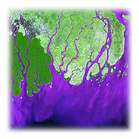
Land and Water
|
|
Bangladesh is a flat country on the delta of three large rivers: The Ganges, the Brahmaputra and the Mehtna. The silt that these three rivers have deposited in the delta means that Bangladesh is a very fertile country. However, the low level of the delta land means that the country is prone to flooding. 75% of Bangladesh is at or below just 10 metres in height. This plain makes up the majority of Bangladesh. Although, there are some hills in the south-east of the country. The east of the country contains thick forest.
|
|
The Weather
|
|
The low land of the Bangladesh delta makes it easy for it to flood. There are two main reasons why flooding can occur: Rivers overflowing and monsoon rains. Interestingly, both of these events happen many hundreds or even thousands of miles away from Bangladesh and there is very little that Bangladesh can do to prevent them from happening.
When a river is carrying too much water, it overflows and floods the surrounding countryside. The Bangladesh delta lies at the end of a very large river basin. If too much water falls anywhere in this river basin system, it is likely that Bangladesh will feel the results. So, if too much snow melts in the Himalaya mountains or if it rains too hard there, that water will ultimately find its way to Bangladesh. Deforestation between the Himalaya mountains and Bangladesh has made the situation even worse. There are less and less trees and vegetation to soak up the excess water and prevent it from reaching the Bangladesh delta.
Monsoon rains are the other factor that causes flooding in Bangladesh. A monsoon means a major shift in the direction of the winds. From October to April, the winds blow from the North-East. However, from April to October they blow from the South-West. These summer winds bring heavy rains with them. Usually, they bring over 80% of Bangladesh's total rainfall with them. Bangladeshi agriculture requires a great deal of water especially for the rice crops. Limited flooding is also good for the farmers as it leaves silt deposits which are rich in nutrients and minerals on the land. It is for this reason that so many farmers live in houses with stilts. However, it is impossible to control the amount of flooding that takes place, if the rains are too heavy, the houses of many hundreds of thousands of people are at risk. Also, the crops will be destroyed. It is a fine line between flooding being a benefit or a catastrophe to the people of Bangladesh.
|
|
|
|
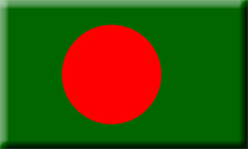
| The Flag of Bangladesh
|
|
Worksheets Available
|
| Example
|
|
Student Work
|
|
Examples of Pieces of Work
|
|
Learning Tasks
|
|
Bangladesh Exercise
|
|
Bangladesh Crossword
|
|
Online Resources
|
Virtual Bangladesh
This is a fun and interesting site that presents a lot of information about Bangladesh. It is all in English.
Bangladesh Overview
This site provides a good introduction to many aspects of Bangladesh.
Bangla 2000
This site provides news and current affairs from Bangladesh
Lonely Planet: Bangladesh
This site has some useful information and some nice pictures of Bangladesh
Statistics about Bangladesh
Some of these are quite difficult to understand, but there are some useful trends for you to look at.
Dhaka
This is an in-depth examination of the City of Dhaka. There are lots of statistics available.
Planet Ark
Use this site to find environmental stories about Bangladesh.
CIA Factbook: Bangladesh
This site is good for facts and figures.
1998 Flood Pictures
1998 saw hugely destructive floods hit Bangladesh.
Maps of Bangladesh
There are many regular and satellite maps for you to look at here.
|
| Facts and Figures
|
| Size
|
144,000 sq km
|
| Highest Point
|
Keokradong 1,230 m
|
| Irrigated Land
|
31,000 sq km
|
| Land Use
|
arable land: 73%
permanent crops: 2%
pastures: 5%
forests & woods: 15%
other: 5% (1993 est.)
|
| Natural Resources
|
natural gas, arable land, timber, coal
|
| Climate
|
tropical; mild winter (October to March); hot, humid summer (March to June); humid, warm rainy monsoon (June to October)
|
| Population
|
131,269,860 (2001)
|
| Life Expectancy
|
60.5
|
| Languages
|
Bangla and English
|
| Literacy Rate
|
56%
|
| Religion
|
Muslim 83%
Hindu 16%
Other 1%
|
| Government
|
Parliamentary Democracy
|
| Capital
|
Dhaka
|
| Currency
|
Taka
|
| Debt
|
$17bn (2000)
|
| Revenue
|
$4.9bn (2000)
|
| Expenditure
|
$6.8bn (2000)
|
| Exports
|
garments, jute and jute goods, tea, leather, frozen fish and seafood
|
| Imports
|
machinery and equipment, chemicals, iron and steel, textiles, raw cotton, food, crude oil and petroleum products, cement
|
|
|
Reference Books
|
Lonely Planet
Lonely Planet Atlas of India and Bangladesh
|
Lonely Planet
Bangladesh |
Johnson, Gordon
Cultural Atlas of India and Bangladesh
|
Novak, James
Bangladesh: Reflections on the Water
|
Ghosh, Roma
Bangladesh
|
|
Chat and Email Discussion Groups
|
Virtual Bangladesh
This is a bulletin board where you can post questions about Bangladesh
Teens of Bangladesh
You can join in discussions with some young Bangladeshis. Posts can be in English or in Bengali
Bangladesh Environmental Network
You can join in serious discussions about the environment and Bangladesh.
|
|