|
|

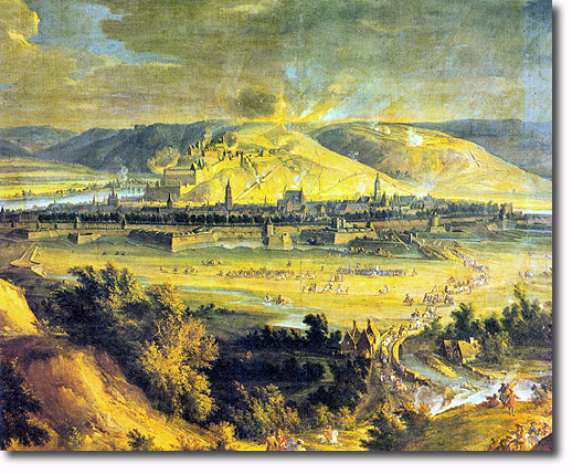 |
| Namur is situated about 50 kilometres south-east of Brussels on the rivers Sambre and Meuse. This painting by J B Martin shows Namur during the the siege of 1692. The Citidel is on a hill beyond the town and just over the Sambre, a smaller tributary of the Meuse which can be seen on the left. The town was fortified and surrounded by a moat. It was besieged twice during this war; the first time was in 1692 when King Louis XIV and his military inventor Sebastien de Vauban captured it from the Dutch engineer, Baron Menho of Coehoorn. It was re-taken in 1695 when it was defended by Louis Francois duc de Bouflers and 14,000 French troops, against an attack by William III and 18,000 Allied troops. During the next 100 years Namur passed back and forth 5 times between French and Allied domination. It was a Dutch town from 1815 and became Belgian in 1830. It was greatly damaged in World Wars I and II. |
Armed Forces | Art and Culture | Articles | Biographies | Colonies | Discussion | Glossary | Home | Library | Links | Map Room | Sources and Media | Science and Technology | Search | Student Zone | Timelines | TV & Film | Wargames
