

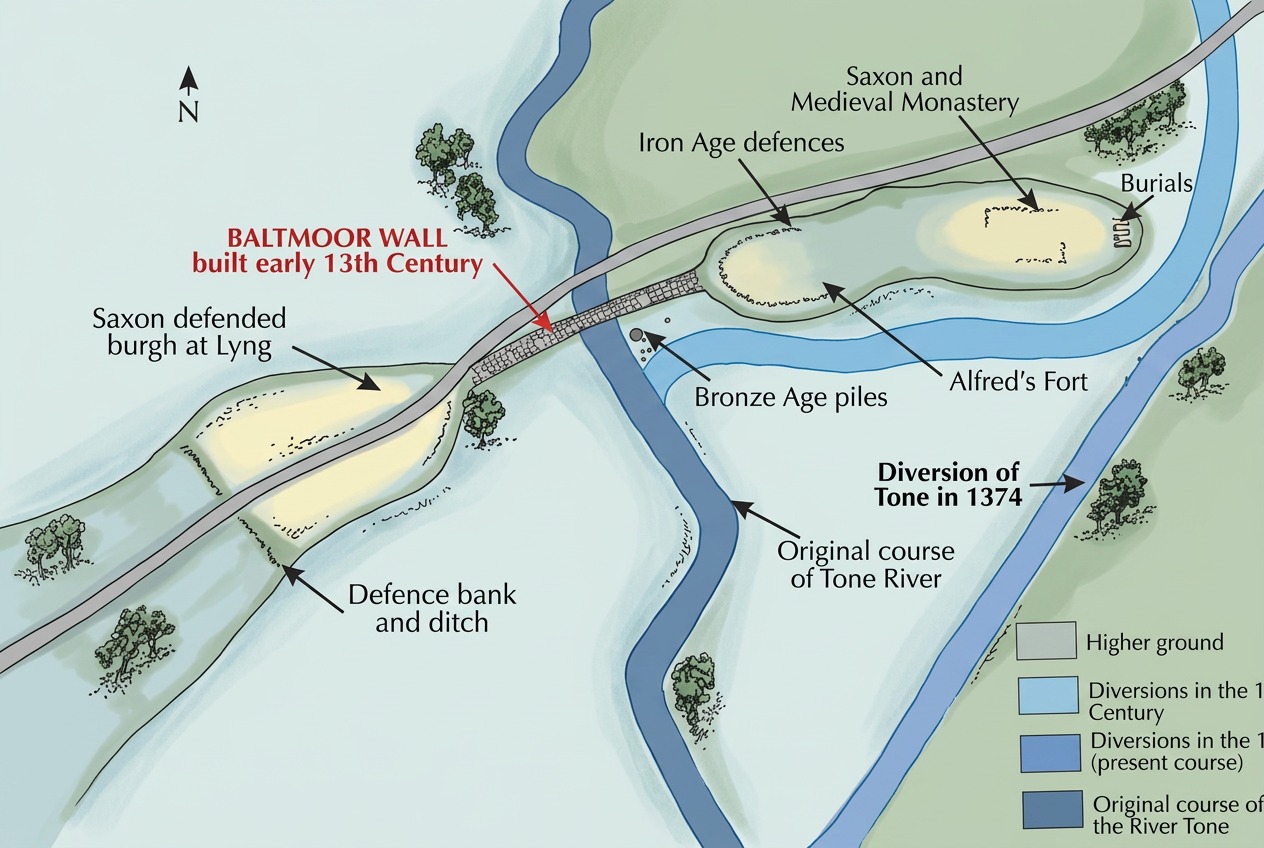
Athelney was the location from which Alfred re‑established effective resistance to the Viking occupation of Wessex in 878. When the Vikings struck at Twelfth Night and seized Chippenham, Alfred disappeared from the record until Easter. Asser states only that he moved through woods and marshes before establishing a fortification at Athelney. The site’s position within the flooded Somerset Levels, combined with its two small summits, provided a defensible island surrounded by waterlogged ground. This made it suitable for a temporary stronghold from which Alfred could reorganise his forces.
The western summit appears to have held Alfred’s fortification. Excavations have revealed evidence of metalworking, indicating that weapons were produced on site. This suggests that Athelney was not simply a hiding place but a functioning military base. The eastern summit later became the location of the abbey founded by Alfred around 882. Asser records that the abbey was well endowed, receiving, together with Shaftesbury, one eighth of Alfred’s taxation income. Asser also describes an attempted murder of the abbot, John the Old Saxon, by two monks, demonstrating that the abbey was an active and significant institution during Alfred’s reign.
Athelney’s earlier history may have influenced Alfred’s choice. The site shows signs of Iron Age occupation, and a hermit named Æthelwine, closely related to seventh‑century West Saxon kings, is recorded as living there. The Old English name æþelingaegge (“isle of the æthelings”) indicates a pre‑existing royal association. The Anglo‑Saxon Chronicle suggests that this name was already in use when Alfred arrived. Athelney’s proximity to the River Parret also aligns with the Chronicle’s record of King Cenwealh driving the Britons to the Parret in 658, which may mark the period when the site’s royal significance developed.
The surrounding high ground—Burrow Mump to the north‑east, Windmill Hill to the south‑west, Oath Hill to the south‑east, and the ridge of Aller Hill—forms a network of observation points. Burrow Mump’s prominence makes it a plausible location for signalling or early warning. Asser’s statement that Alfred struck out at Vikings from Athelney implies that Viking forces were operating close by, making such vantage points strategically relevant.
The Anglo‑Saxon Chronicle states that Alfred left Athelney for Egbert’s Stone in the seventh week after Easter. This places him at the fortress for roughly seven weeks, although he may have reached the site earlier. His movements between January and Easter remain unknown. Several routes from Chippenham to Athelney are possible, including via Bath and the Fosse Way, or through Selwood Forest, which would satisfy Asser’s description of wooded and marshy terrain.
The later legend of Alfred burning the cakes is not supported by contemporary evidence. The earliest known version appears in the late tenth‑century Vita S Neoti and cannot be securely linked to Athelney. The site’s documented history is instead military, monastic, and strategic.
Athelney was connected to East Lyng by a causeway, and the defensive system of Lyng will be addressed separately. Time Team’s two investigations confirmed the abbey’s location on the eastern summit and uncovered human remains that post‑dated parts of the abbey structure. These finds are most likely associated with the medieval monastic occupation rather than earlier phases of activity.

