

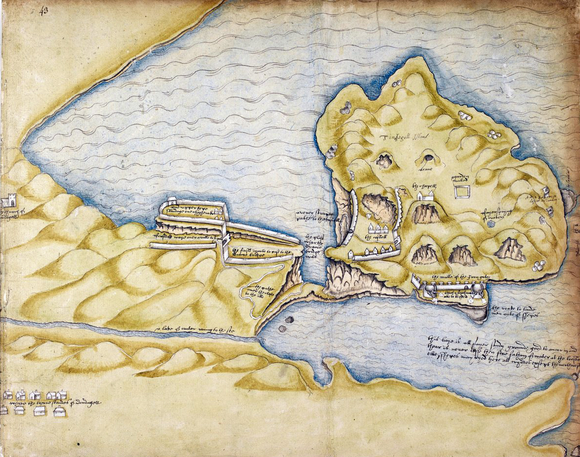
One of the most valuable records of Tintagel Castle is an Elizabethan survey drawn for Sir Richard Grenville around 1583. At first glance it appears to be a simple estate map, but it preserves details of the site which have since been altered or lost altogether through centuries of Atlantic erosion. For anyone interested in the history of Tintagel, it provides a snapshot of the castle at a moment when Richard of Cornwall's ambitious project was already becoming a ruin, but before nature had completed much of the destruction visible today.
The most striking feature of the map is that Tintagel is already shown as an island separated from the mainland by a narrow sea channel. When Richard of Cornwall built the castle in the thirteenth century, the situation appears to have been different. Geological evidence suggests that the island was originally connected to the mainland by a natural ridge of rock. Rather than crossing a bridge, visitors could have walked directly onto the headland. This made far more sense for the operation of a castle which was intended to impress noble guests and reinforce Richard's connection with Cornwall's legendary past.
At some point during the late medieval period this natural connection collapsed. Exposed to centuries of Atlantic storms, the narrow neck of rock gradually weakened until it finally gave way. By Grenville's time the process was complete. The map clearly shows water separating the mainland from the island, with access gained only via a steep and narrow crossing. The site had become considerably more isolated than Richard of Cornwall ever intended.
This physical separation accelerated the castle's decline. Richard's castle had never been particularly important militarily and after his death it rapidly lost much of its political significance. Maintaining buildings in such an exposed location was challenging at the best of times. Once access became more difficult, repairs became less attractive and less economical. Roofs disappeared, walls collapsed and vegetation began reclaiming the site.
Grenville's map nevertheless reveals a castle more substantial than the ruins visitors encounter today. The drawing outlines defensive walls, pathways, enclosures and structures which have either disappeared completely or survive only as faint archaeological traces. The layout of the outer defences is particularly informative. Sections of wall shown on the survey have since been lost to cliff falls and coastal erosion. The map therefore preserves evidence for parts of Richard's castle that no longer exist.
The survey also demonstrates how carefully the medieval castle occupied the landscape. Buildings and walls were arranged around the natural topography of the headland. The island is crowded with features: the chapel, enclosed areas, defensive works and trackways. Modern visitors often see Tintagel primarily as a collection of scattered ruins rising from the turf. Grenville's plan reminds us that it was once a far more complex and interconnected place.
Ironically, the very process that damaged the castle also enhanced its reputation. During the eighteenth and nineteenth centuries, artists, writers and antiquarians increasingly valued picturesque ruins. A well-preserved medieval castle might impress through its architecture. A shattered castle perched on sea cliffs appealed to the Romantic imagination.
Tintagel proved almost perfectly suited to these tastes. Visitors arriving during the Romantic era encountered crumbling walls standing above crashing waves, isolated from the mainland by a dramatic chasm. The ruins appeared ancient, mysterious and inseparable from the legends of King Arthur and Tristan. The destruction caused by centuries of neglect and erosion actually strengthened the atmosphere people hoped to experience.
This fascination was enhanced by the growing popularity of Arthurian literature during the nineteenth century. Poets, painters and travellers sought locations which seemed to embody Britain's legendary past. Tintagel offered precisely that combination of myth and landscape. The broken remnants of Richard of Cornwall's castle appeared less like the remains of a thirteenth-century nobleman's political statement and more like the fading relic of Arthur's own age.
Grenville's survey allows us to stand between these two worlds. It records a castle already abandoned and partially ruined, yet still substantially more complete than it is today. It captures the consequences of the collapse of the land bridge and the increasing isolation of the headland. At the same time, it marks the beginning of the transformation that would make Tintagel famous. The Atlantic was slowly dismantling Richard of Cornwall's castle, but in doing so it was creating one of Britain's most evocative historic landscapes. By the time the Victorians arrived in search of Arthur and medieval romance, nature had already done much of the work for them.

