

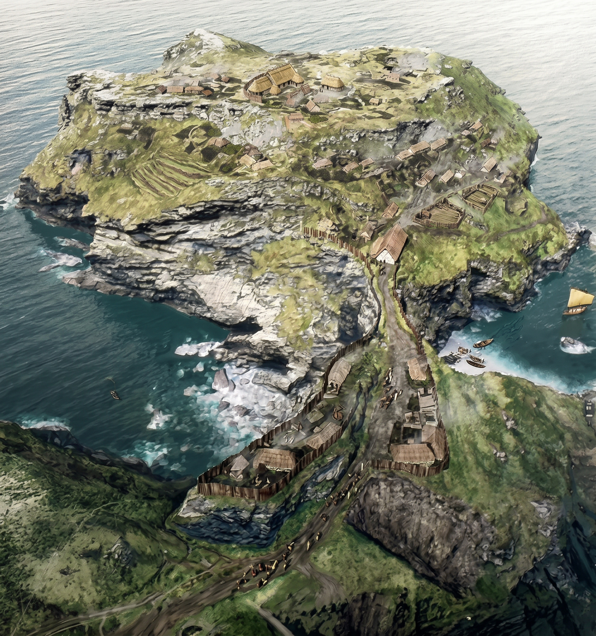
Ask most visitors who ruled Cornwall before the Normans and you will get a blank look, or else the name of a king who never existed. The truth is that for several centuries after the Romans left, the south-west of Britain was a kingdom in its own right, known to its neighbours as Dumnonia. It took its name from the Dumnonii, the tribe that the Romans had found there, and at its height it covered Cornwall, Devon and a slice of western Somerset. Its people spoke a British tongue that was the ancestor of both Cornish and Breton. What the kings of Dumnonia lacked was a chronicler, and so they survive mostly as shadows in the margins of other people's books. Archaeologists have spent the better part of a century trying to discover more about them. The image above is a speculative rendition of what their settlement on Tintagel Head may have looked like in the 6th or 7th century.
The archaeology story begins in the 1930s, when Ralegh Radford spent six summers digging on the island and turned up something nobody had expected. Among the later medieval rubble were thousands of fragments of pottery, and much of it had been made on the far side of Europe. There were bowls of fine red tableware from the eastern Mediterranean, and the shards of great storage jars, amphorae, that had carried wine and olive oil a thousand miles or more by sea. Cornwall was not supposed to have such things in the fifth and sixth centuries, when Britain was meant to have slid into poverty and obscurity once the legions had gone. Radford made sense of his discovery in the way that was natural for his time. The buildings were small and the island was remote, and he knew that the Irish had founded monasteries on remote rocky islands, so he decided that Tintagel had been a Celtic monastery. It was a reasonable guess and it stood for the best part of sixty years.
The first serious cracks appeared in the 1990s, when a team from Glasgow went back to the island to examine his work and to dig where he had not. On one small terrace of the cliff, the pottery from the Mediterranean made up more than four finds in every five, which tells you a good deal about what sort of place it was. Then in 1998 came the slate. It was a scrap with letters scratched on it, a sixth-century piece of scribbling that included at least three names, and one of them read ARTOGNOU. You can imagine the headlines. Artognou, a bear-name, looked enough like Arthur for the newspapers to christen it the Arthur stone, and the archaeologists had to explain patiently, and rather wearily I suspect, that the name was a perfectly ordinary British one of its day. But the more interesting point was missed in the noise. Somebody on that cliff in the Dark Ages could write, and not just in a monastery, since the writing was done in Latin letters among the ordinary debris of a settlement. It was a literate and well-connected society, and the people who lived there plainly had plenty of wine.
The most recent digs, begun in 2016, finished off the monastery. Under the turf they found walls and paving and flights of steps, hundreds more sherds of imported pottery, and pieces of fine glass of the sort that no humble religious community would have been drinking from. The consensus now is that the island was a secular stronghold and a royal one, probably a seasonal residence of the kings of Dumnonia, who were rich because of the metal that lay under their ground. Tin is thought to have been what Cornwall sent in return for all that wine and oil, travelling along a sea route that ran up the Atlantic coast to Gaul and on to the Mediterranean. Seen like that, the choice of Tintagel begins to look less eccentric. It has a cliff on every side and a landing place in the Haven below, and it sits where a ship coming up the coast could not fail to see it. I find it hard not to wonder whether Geoffrey of Monmouth, when he put his Duke of Cornwall in a castle at Tintagel in the twelfth century, was working from some half-remembered notion that this was where the old Cornish rulers had once held court. Cornwall has at least one other glimpse of such a ruler, on the stone near Fowey that commemorates Drustanus, the son of Cunomorus, and Cunomorus has often been identified with the original of King Mark. That is rather a lot of Tristan for one stretch of coast.
All of which leaves the question of what became of the dead, and that is where the churchyard comes in. St Materiana's stands on the cliff just across the neck of land from the island, and around it, on the north and east sides, are a number of low grassy mounds that look very much like prehistoric barrows. They are the earthworks that the surveyor of the old map seems to have had in mind when he wrote Camp, and for a long time they were assumed to be the remains of a Roman signal station. Then in 1942 two of five mounds were opened and found to contain burials laid in slate-lined graves, at a considerable depth. That was not how the Romans buried anybody, and it began to look as if the mounds were the cemetery of the people who lived on the island. Proper excavation in 1990 of one of the mounds, known as Mound C, confirmed it. Under it lay two long-cist graves, stone-lined and aligned west to east in the Christian manner, and they have been dated to the fifth or sixth centuries, which makes them the earliest burials yet known in the neighbourhood of the church.
It is a pleasing thing to realise that the island and the churchyard are two halves of the same picture. The living inhabitants of the Dark Age settlement dwelt on the headland among their imported wine jars, and when they died they were carried across the narrow neck and buried in ground that was already becoming sacred. Radford's monastery was wrong, but the people on his island were Christians all the same, and the evidence for it was lying in plain view on the mainland. The tradition that Materiana, the saint of the church, was a Welsh princess who evangelised the district around the year 500 may be no more than a legend, but the legend and the archaeology happen to agree about the date. Then a thousand years later and more, the Normans raised a church on the spot, and so the same few acres have been receiving the dead for something like fifteen hundred years. The Roman milestone that now stands in the south transept, bearing the name of the emperor Licinius, is a reminder that the ground was marked out in an even earlier age, since a Roman road evidently passed somewhere nearby.
There is a lesson in this, I think, and it is a slightly different one from the lesson of the map. The Victorian surveyor wrote Camp and walked on whilst the graves of the first Christians of Tintagel lay beneath his feet. Radford saw Mediterranean pottery and imagined monks. Each of them was a careful observer who had grasped part of the truth and had no way of knowing the rest. What we have gained in the last thirty years is not a better king, because Arthur has remained exactly as elusive as he was before, but something I would have found more satisfying all along, a picture of real people. They were traders, readers, rulers and mourners, living on a cliff at the edge of the known world and linked by sea to places as far away s Constantinople. It is a curious fate that the legend of a king who probably never lived should have kept so many visitors coming to a place where the genuinely extraordinary thing is the people who really did.

