

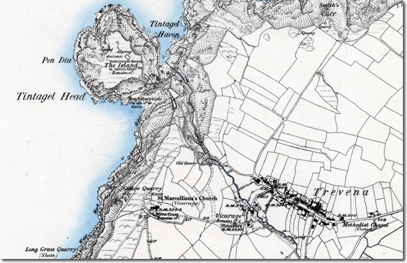
This 19th Century map reveals as much about the Victorian era as it does the geography of the area. A surveyor in the nineteenth century was not writing a guidebook or selling a legend. He was walking the ground, writing down what he could see and what the locals told him things were called. That makes this old map of Tintagel a fascinating document, because it has the myth and the reality sitting side by side on the same sheet, often without anyone realising they were in tension. Set beside the modern landscape, it shows just how much of what we now think of as Tintagel is the product of a particular age's hopes and desires.
The first thing that strikes you is that the village of Tintagel is not there at all. In its place, in wide and stately lettering, is the name Trevena, which as I mentioned in my main article was what the community was called for most of its history. The name Tintagel belonged to the headland and its castle, and so that is where it appears on the map, attached to Tintagel Head and Tintagel Haven but not to a single house. It is generally explained as referring to the narrow neck of land that once joined the promontory to the cliffs, although I would not want to be dogmatic about the etymology. Interestingly, the distinction made perfect sense and it was about to be abandoned. The Romantic visitors, drawn by King Arthur and by Tristan and Isolde, wrote home from Tintagel, assuming that village and castle were one and the same, and the Post Office eventually followed the tourists rather than the villagers. The map seems to have caught the two names at the very moment of their parting: the old name for the place where people lived and the famous name for the place that people came to see. Within a few decades the second had all but swallowed the first.
The parish church fares no better, and here the surveyor will strike anyone who has stood in its porch as faintly wrong, for he calls it St. Marcelliana's. The church we visited is St Materiana's, and the two names are really one saint caught in different spellings. She has turned up over the centuries as Materiana, Marcelliana, Merteriana and in other forms besides, which is what tends to happen to a saint who is remembered fiercely in one place and scarcely anywhere else. Nobody can say for certain who she was. Later tradition made her a Welsh princess, a daughter of Vortimer, though that rests on little more than the pleasing habit of supplying obscure saints with distinguished parents, and some have suggested she is the same person as the Welsh Madrun. Whatever the truth, the spelling that reached the surveyor's notebook was the one he heard or the one he found in use, and he wrote it down with the same confidence with which he wrote down everything else. It is a small reminder that even something as solid as a church dedication was less fixed than we assume, and that St Materiana is a spelling that won out rather than one that was always there.
A little north of the church, among the fields, there is a single word: Camp. The modern map marks the very same field as an earthwork, and it is the field that Rupert and I wandered around on our visit. It was here in the 1950s that excavation revealed graves, the remains of an early church and a Christian burial ground of remarkable age. The Victorian surveyor knew nothing of this. He simply saw banks and hollows of obvious regularity and gave them the label reserved for such things, a military camp of the prehistoric or Roman variety. His interpretation was wrong, but his observation was perfectly sound. The earthwork was obvious to anyone who walked the ground and he recorded it faithfully. It just had to wait a century for somebody to work out what it really was. There is a nice irony too in the fact that this same field gave J.L. Carr part of the inspiration for A Month in the Country, a novel about precisely this kind of archaeological discovery.
The labelling of the headland is more revealing still. At the neck of the promontory, where the ruins lie, the surveyor has written King Arthur's Castle, and underneath it in smaller type, on site of a Camp. The name Tintagel Head is kept for the headland as a whole, and the plateau beyond is simply The Island. The Arthurian title is the Romantic nineteenth century in two words. By the time of the survey, the ruins had been a literary destination for generations, visited and painted and written about, and the name that the visitors had given them had hardened into the one that an official map was happy to print. Nothing, though, could be less certain than the claim it makes. The castle was built in the 13th century by Richard of Cornwall, who had very little need of a defensive fortress on such a remote headland but a great deal of use for a connection with the legendary kings of his earldom. His castle was always more symbolic than defensive, and the Arthur it flattered was largely the invention of Geoffrey of Monmouth.
It is worth noticing that the surveyor's second phrase, on site of a Camp, is actually closer to the truth than the first. Beneath the 13th century ruins lay a settlement of far greater antiquity, an important Dumnonian stronghold of the post-Roman centuries whose inhabitants were importing wine and fine pottery from the Mediterranean. Nobody in the nineteenth century could possibly have known this, and I suspect the word Camp simply reflects a general sense that something older lay beneath the later stones. The other labels on the island follow the same pattern of partial understanding. We can see the Remains of St. Julitta's Chapel, the Enclosure, the Subterranean Passage and the Springs, and several of these features were probably arranged by Richard's builders to match episodes in the story of Tristan and Isolde so that he could show his guests the very garden, chapel and cave from the romance. Another entry, near the vicarage in the village, records the Remains of a Monastery, reflecting a long-held belief that the island had housed a Celtic religious community. That belief has since given way to the view that the island was a secular and probably royal site. The monastery, like the Arthurian castle, belongs as much to the history of interpretation as to the history of the place.
So the map is really a record of three kinds of knowledge: what the surveyor could see, what he was told, and what he could not possibly have known. The earthworks were seen and recorded correctly, if misunderstood. The names Trevena and King Arthur's Castle were told to him, and they preserve an older local tradition and a newer literary one respectively, while the shifting spelling of the church's saint shows how loosely even a very old name could be carried along by word of mouth. The Dark Age settlement beneath the ruins was beyond his knowledge altogether and has only been uncovered by the patient work of later archaeologists. A great deal has changed since the sheet was drawn. The village has taken the name of the castle, the island has been reconnected to the mainland by the bridge of 2019, and the Arthur of the old label has acquired a bronze companion in the statue called Gallos, which most visitors assume is the king himself. What has not changed is the habit of mind that the map exposes, the tendency of every generation to look at the same ground and see what it has been prepared to see. It is a modest lesson but a salutary one, and the real history of Tintagel has turned out to be every bit as remarkable as the legends that once concealed it.

